Good noontime,
Last night, smoke blew in from fires burning to our west (mostly from Idaho), and we briefly saw conditions in Missoula County reach Unhealthy for Sensitive Groups levels. Fortunately, it didn’t last, and we’ve been sitting at Moderate since the wee hours of the morning. Our neighbors to the south have not been so lucky. There is a large new fire burning west of Hamilton, and it sent significant amount of smoke into the Bitterroot last night. The smoke was trapped in the valley overnight, and conditions ranged from Unhealthy to Very Unhealthy this morning. The smoke is starting to lift, and while air quality is still Unhealthy down there, conditions should improve by this afternoon. However, westerly breezes will likely continue to deliver smoke from that fire to the Bitterroot for the near future. (There is very little information available about the fire west of Hamilton. It currently looks to be the called Wye-MCRD Fire, but that’s all I have for you.)
Meanwhile, the Bass Creek Fire is burning in the Bitterroots between Florence and Stevensville. Depending on how that fire grows, we can expect to see even more smoke in the Bitterroot Valley. Smoke from the Bass Creek Fire will follow the drainage to the Hwy 93 corridor in the evenings, and Stevensville, Florence and potentially Lolo may all be impacted on a nightly basis. (The Bass Creek Fire is still relatively small, and with luck and firefighters’ efforts it will stay that way. If not, be prepared for recurring smoke impacts.)
With the high pressure ridge finally (and dramatically) broken down, we are seeing a return to more active weather. While this doesn’t look to include much rain in the future, it does mean the air itself will move more easily. This leads to a few things. First, the good news: Without high pressure keeping a lid on things and making the air all sluggish, we have a chance for pretty good smoke clearing some days. As long as we aren’t directly downwind of a plume, there are opportunities for pretty good air. The bad news is twofold: 1) fires can put out significant plumes under an active atmosphere, and 2) we are downwind of fires in Idaho, Oregon and Washington. We will be under westerly breezes for the next several days, and we may see smoke arriving from out of state in the afternoons and evenings.
Based on the number of fires west of us, this afternoon might be the best air we see for the next few days. This morning’s inversion is breaking and the light smoke we had this morning is lifting up. Hurry out quick like a bunny and enjoy the (hopefully) clean air before smoke arrives later today or tomorrow!
Conditions may change rapidly, so pay close attention to current air quality. You can check conditions at the Fire and Smoke Map and use your eyeballs and nose holes. If you’re seeing and smelling smoke, that’s a good indicator that you should check the nearest air monitor and take measures to reduce your exposure. When conditions deteriorate, seek cleaner air. Head inside, close doors and windows, and use a HEPA portable air cleaner, DIY air cleaner, or your HVAC system to clean the indoor air! Visit www.montanawildfiresmoke.org for helpful tips!
Finally, there’s an important PSA about the storm aftermath and cleanup below today’s photos!!
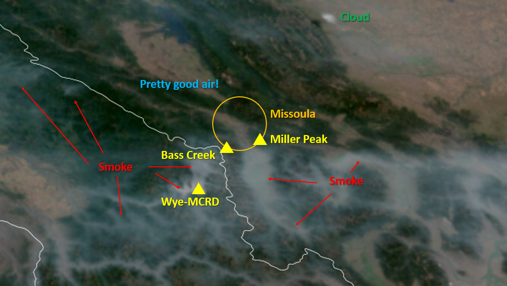
In this late morning satellite photo, you can see smoke from the Wye-MRCD fire trapped in Idaho valleys as wells as the Bitterroot Valley. There is currently good air in the Missoula County area, but fires burning west of our region may send smoke our way later today or tonight. Photo credit: NOAA
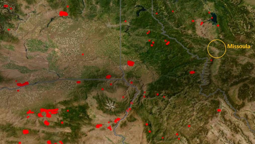
This morning’s heat detection map gives you an idea of the fires burning west of our area. As the day progresses, those fires will wake up and start sending out plumes, some of which will be headed our way. Photo credit: NASA
Are you finding yourself suddenly surrounded by branches and don’t know what to do with them? The County and City Public Works Departments have debris pick up and drop off details below! Photo credit: Sarah Coefield
Storm Aftermath and Cleanup PSA from Missoula County:
LIMIT WATER USE: Residents and businesses need to conserve water, particularly in the South Hills and Lewis and Clark areas. Missoula Water is still running on generators, and only 50% of water tanks are currently online. Residents should not water their lawns, and limit domestic use. This includes limiting use of washing machines and dishwashers and showers/baths.
STILL CHECK ON YOUR NEIGHBORS: 9-1-1 is still busy taking many calls, and if you’re able to help your neighbors, this allows emergency resources and dispatchers to prioritize emergencies efficiently.
DEBRIS MANAGEMENT: County and City Public Works continue to prioritize debris pick up in public rights-of-way, including streets/roads, sidewalks and alleys.
Officials are working to set up public debris drop sites in Lolo, Frenchtown and Seeley Lake.
The drop-off sites listed below remain available for residents to drop-off debris from the storm at no cost. They will be open for the next two weeks; certain sites have designated hours. The Playfair Park location is no longer available; officials are working on to set up another location.
People should use the Garden City Compost site when possible, as all the debris dropped off at the other sites ends up there. Officials are working on extending the hours there.
- Garden City Compost (1125 Clark Fork Lane, open 8-5 Friday and Saturday)
- Fort Missoula (36th Street lot)
- Larchmont triangle (access of Post Siding Road)
- McCormick Park (east lot)
- Fort Missoula Ponds (access via 40th Avenue, open 8 a.m. to 5 p.m.)
Only dump debris in designated areas and follow all on-site instructions.
PSA from me: Remember, no matter how tempted you may be, and no matter where you are in the county, DO NOT set your sudden abundance of trees and branches on fire!
Breathe safe!