
Wildfire Smoke Update July 23, 2024

Blue skies are quite the treat after a smoky weekend and start to the week! Well, I guess it’s not quite a blue bird day, but there is some blue shining through the layer of haze. Yesterday, the air quality for a large portion of the day was Unhealthy for Sensitive Groups. Good news is that the GOES 18 satellite imagery shows some stronger westerly to southwesterly winds moving mostly fresher air and clearer skies to Missoula, but there is still some smoke in the air being transported here mainly from fires in Washington, Oregon, and California keeping Missoula area at Moderate air quality.

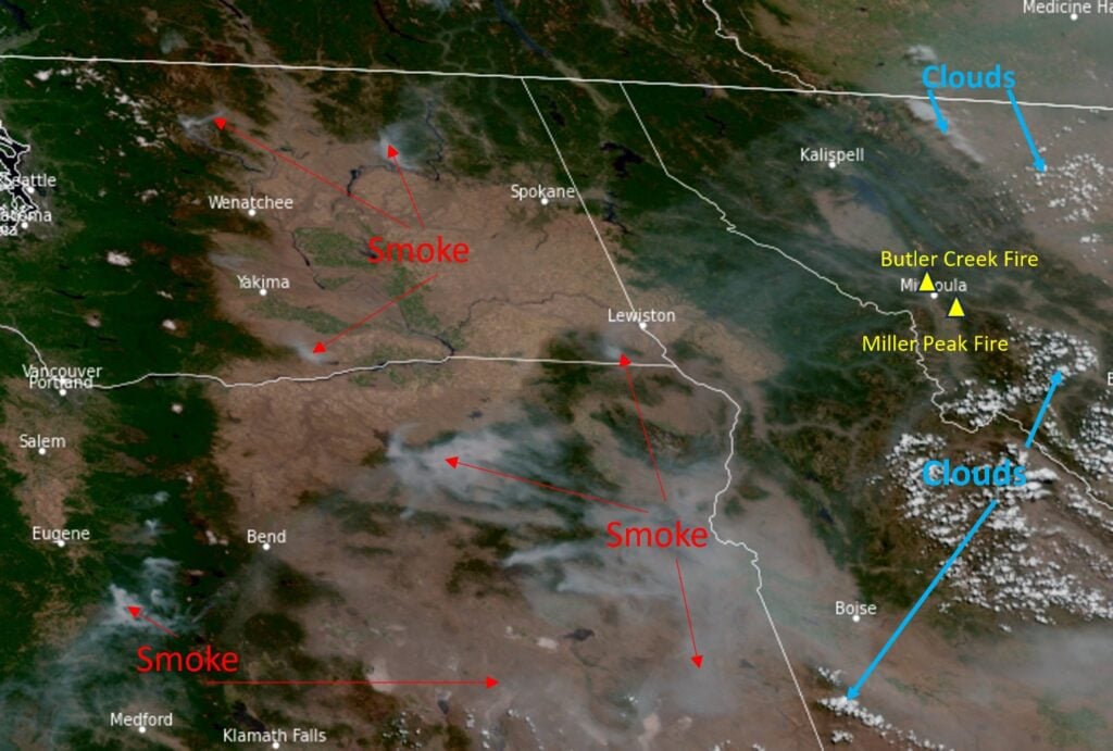
Scattered air quality sensors on the Fire and Smoke Map from Frenchtown to Missoula are oscillating between Moderate and Unhealthy for Sensitive Groups. The air may clear up to Moderate across Missoula County this evening with stronger gusts of wind coming. Although there are strong gusts of wind this evening, the forecast is predicting very calm winds later tonight until early afternoon tomorrow. This means a couple things. One, people closest to the Butler Creek Fire and the Miller Peak Fire will likely still see smoke traveling down drainages and pooling in low areas and valleys. And two, that smoke pooled in the valley might stick around longer, especially if an inversion sets up, restricting air movement and the mixing of surface level air into the upper atmosphere. Once the wind picks up in the afternoon, any inversion set up should break.

Thursday there will be strong gusts of wind in the afternoon that will help clear out the area of smoke (if the wind is clear of smoke) but can make fighting wildfires a lot more difficult. The National Weather Service has issued a Red Flag Warning for tomorrow due to the combination of low humidity, likelihood of thunderstorms, and strong gusts of wind. To prevent further wildfires, there are currently Stage II Restrictions across Missoula County which means no recreational fires, no outdoor burning, hoot owl restrictions on gas powered equipment and more. Review the full list at MTfireinfo.org and recreate responsibly.

Those high temperatures are not only concerning for more wildfire starts, but they are really hard on our health – there is currently a Heat Advisory issued by the National Weather Service from now until Thursday night. Heat is immediately dangerous and causes heat stress and heat related illnesses. When battling heat and smoke, address heat first and then smoke. Stay hydrated and take breaks inside places with cooled and filtered air. If you need to cool your home, open your windows at night and run your air cleaner, ideally in the room you sleep in. Visit Montanawildfiresmoke.org for more information on cleaning your indoor air and how smoke effects your health and check out past air quality updates.

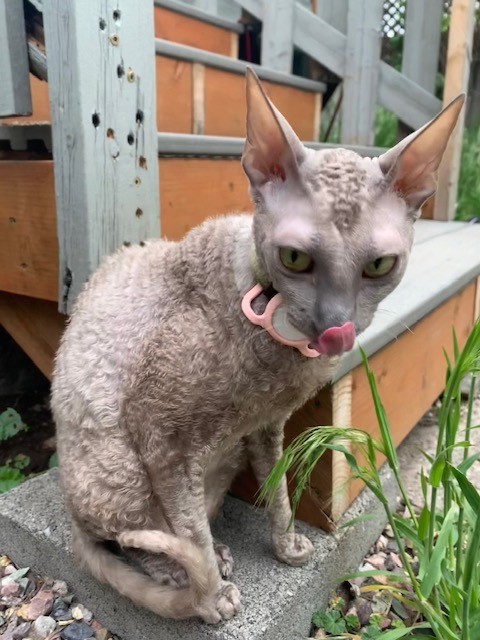
Mushu, your local air quality, encourages everyone to check the air monitors before getting outside and to take advantage of any break from smoke we get! One of her favorite activities is bolting out the door to go eat grass; yours might be a trail run or a lap around the block. Whatever it may be, inside or out, remember that smoke affects everyone differently so watch out for each other and breathe safe!

\r\n\r\n<\/div>"},"imageFolderURL":"https:\/\/missoulapublichealth.org\/wp-content\/plugins\/wp-google-maps\/images\/","resturl":"https:\/\/missoulapublichealth.org\/wp-json\/wpgmza\/v1","restnonce":"771212afeb","restnoncetable":{"\/(polygons|polylines|circles|rectangles|pointlabels)(\\\/\\d+)?\/":"eaf7fa9e2b","\/markers(\\\/\\d+)?\/":"6be066e01c","\/datatables":"1096539db4"},"settings":{"engine":"google-maps","internal_engine":"legacy","google_maps_api_key":false,"default_marker_icon":"https:\/\/missoulapublichealth.org\/wp-content\/plugins\/wp-google-maps\/images\/spotlight-poi3.png","developer_mode":false,"user_interface_style":"default","wpgmza_gdpr_enabled":1,"wpgmza_gdpr_default_notice":"

\r\n\tI agree for my personal data to be processed by <\/span>, for the purpose(s) of <\/span>.\r\n<\/p>\r\n\r\n

\t\r\n\tI agree for my personal data, provided via map API calls, to be processed by the API provider, for the purposes of geocoding (converting addresses to coordinates), reverse geocoding and\tgenerating directions.\r\n<\/p>\r\n

\r\n\tSome visual components of WP Go Maps use 3rd party libraries which are loaded over the network. At present the libraries are Google Maps, Open Street Map, jQuery DataTables and FontAwesome. When loading resources over a network, the 3rd party server will receive your IP address and User Agent string amongst other details. Please refer to the Privacy Policy of the respective libraries for details on how they use data and the process to exercise your rights under the GDPR regulations.\r\n<\/p>\r\n

\r\n\tWP Go Maps uses jQuery DataTables to display sortable, searchable tables, such as that seen in the Advanced Marker Listing and on the Map Edit Page. jQuery DataTables in certain circumstances uses a cookie to save and later recall the \"state\" of a given table - that is, the search term, sort column and order and current page. This data is held in local storage and retained until this is cleared manually. No libraries used by WP Go Maps transmit this information.\r\n<\/p>\r\n

\r\n\tPlease see here<\/a> and here<\/a> for Google's terms. Please also see Google's Privacy Policy<\/a>. We do not send the API provider any personally identifying information, or information that could uniquely identify your device.\r\n<\/p>\r\n

\r\n\tWhere this notice is displayed in place of a map, agreeing to this notice will store a cookie recording your agreement so you are not prompted again.\r\n<\/p>","wpgmza_gdpr_company_name":"Missoula Public Health","wpgmza_gdpr_retention_purpose":"displaying map tiles, geocoding addresses and calculating and display directions.","wpgmza_gdpr_button_label":"I agree","wpgmza_marker_xml_url":"https:\/\/missoulapublichealth.org\/wp-content\/uploads\/wp-google-maps\/","wpgmza_maps_engine":"google-maps","wpgmza_maps_engine_dialog_done":true,"wpgmza_google_maps_api_key":"QUl6YVN5QXJINkVnQ0JBd3NBX3JybjBtVWhJVng4elFUSkU1MlIw","tile_server_url":"https:\/\/{a-c}.tile.openstreetmap.org\/{z}\/{x}\/{y}.png","action":"wpgmza_save_settings","wpgmza_settings_map_full_screen_control":false,"wpgmza_settings_map_streetview":false,"wpgmza_settings_map_zoom":false,"wpgmza_settings_map_pan":false,"wpgmza_settings_map_type":false,"wpgmza_settings_map_tilt_controls":false,"wpgmza_settings_map_scroll":false,"wpgmza_settings_map_draggable":false,"wpgmza_settings_map_clickzoom":false,"wpgmza_settings_cat_logic":"0","wpgmza_settings_filterbycat_type":"1","use_fontawesome":"4.*","tile_server_url_override":"","wpgmza_load_engine_api_condition":"where-required","wpgmza_always_include_engine_api_on_pages":"","wpgmza_always_exclude_engine_api_on_pages":"","wpgmza_prevent_other_plugins_and_theme_loading_api":false,"wpgmza_settings_access_level":"manage_options","wpgmza_settings_retina_width":"","wpgmza_settings_retina_height":"","wpgmza_force_greedy_gestures":false,"disable_lightbox_images":false,"gallery_item_source_size":null,"wpgmza_settings_image_resizing":false,"wpgmza_settings_image_width":"","wpgmza_settings_image_height":"","wpgmza_settings_infowindow_width":"","wpgmza_settings_infowindow_links":false,"wpgmza_settings_infowindow_address":false,"infowindow_hide_category":false,"wpgmza_settings_infowindow_link_text":"","wpgmza_settings_map_open_marker_by":"1","wpgmza_settings_disable_infowindows":false,"wpgmza_settings_markerlist_icon":false,"wpgmza_settings_markerlist_link":false,"wpgmza_settings_markerlist_title":false,"wpgmza_settings_markerlist_address":false,"wpgmza_settings_markerlist_category":false,"wpgmza_settings_markerlist_description":false,"wpgmza_do_not_enqueue_datatables":false,"wpgmza_default_items":null,"wpgmza_settings_carousel_markerlist_theme":null,"wpgmza_settings_carousel_markerlist_image":false,"wpgmza_settings_carousel_markerlist_title":false,"wpgmza_settings_carousel_markerlist_icon":false,"wpgmza_settings_carousel_markerlist_address":false,"wpgmza_settings_carousel_markerlist_description":false,"wpgmza_settings_carousel_markerlist_marker_link":false,"wpgmza_settings_carousel_markerlist_directions":false,"wpgmza_settings_carousel_markerlist_resize_image":false,"carousel_lazyload":false,"carousel_autoheight":false,"carousel_pagination":false,"carousel_navigation":false,"wpgmza_do_not_enqueue_owl_carousel":false,"wpgmza_do_not_enqueue_owl_carousel_themes":false,"carousel_items":"5","carousel_items_tablet":"3","carousel_items_mobile":"1","carousel_autoplay":"5000","wpgmza_store_locator_radii":"","importer_google_maps_api_key":"","open_layers_api_key":"","open_route_service_key":"","wpgmza_settings_marker_pull":"0","wpgmza_custom_css":"","wpgmza_custom_js":"","disable_compressed_path_variables":false,"disable_autoptimize_compatibility_fix":false,"enable_dynamic_sql_refac_filter":false,"disable_automatic_backups":false,"disable_google_fonts":false,"wpgmza_developer_mode":false,"wpgmza_gdpr_require_consent_before_load":false,"wpgmza_gdpr_override_notice":false,"wpgmza_gdpr_notice_override_text":"","accessLevel":"manage_options","alwaysExcludeEngineApiOnPages":"","alwaysIncludeEngineApiOnPages":"","carouselAutoplay":"5000","carouselItems":"5","carouselItemsMobile":"1","carouselItemsTablet":"3","carouselMarkerlistResizeImage":false,"carouselTheme":null,"categoryFilterDisplay":"dropdown","categoryFilteringLogic":"or","customCss":"","customJs":"","defaultMarkerIcon":"https:\/\/missoulapublichealth.org\/wp-content\/plugins\/wp-google-maps\/images\/spotlight-poi3.png","developerMode":false,"disableAutomaticBackups":false,"disableAutoptimizeCompatibilityFix":false,"disableCompressedPathVariables":false,"disableDoubleClickZoom":false,"disableDragPanning":false,"disableFullScreenControl":false,"disableGoogleFonts":false,"disableInfoWindows":false,"disableLightboxImages":false,"disableMouseWheelZoom":false,"disablePanControl":false,"disableStreetViewControl":false,"disableTypeControl":false,"disableZoomControl":false,"doNotEnqueueDatatables":false,"doNotEnqueueOwlCarousel":false,"doNotEnqueueOwlCarouselThemes":false,"enableCarouselAutoHeight":false,"enableCarouselLazyLoad":false,"enableCarouselNavigation":false,"enableCarouselPagination":false,"enableDynamicSqlRefacFilter":false,"forceGreedyGestures":false,"galleryItemSourceSize":null,"gdprButtonLabel":"I agree","gdprCompanyName":"Missoula Public Health","gdprDefaultNotice":"

\r\n\tI agree for my personal data to be processed by <\/span>, for the purpose(s) of <\/span>.\r\n<\/p>\r\n\r\n

\t\r\n\tI agree for my personal data, provided via map API calls, to be processed by the API provider, for the purposes of geocoding (converting addresses to coordinates), reverse geocoding and\tgenerating directions.\r\n<\/p>\r\n

\r\n\tSome visual components of WP Go Maps use 3rd party libraries which are loaded over the network. At present the libraries are Google Maps, Open Street Map, jQuery DataTables and FontAwesome. When loading resources over a network, the 3rd party server will receive your IP address and User Agent string amongst other details. Please refer to the Privacy Policy of the respective libraries for details on how they use data and the process to exercise your rights under the GDPR regulations.\r\n<\/p>\r\n

\r\n\tWP Go Maps uses jQuery DataTables to display sortable, searchable tables, such as that seen in the Advanced Marker Listing and on the Map Edit Page. jQuery DataTables in certain circumstances uses a cookie to save and later recall the \"state\" of a given table - that is, the search term, sort column and order and current page. This data is held in local storage and retained until this is cleared manually. No libraries used by WP Go Maps transmit this information.\r\n<\/p>\r\n

\r\n\tPlease see here<\/a> and here<\/a> for Google's terms. Please also see Google's Privacy Policy<\/a>. We do not send the API provider any personally identifying information, or information that could uniquely identify your device.\r\n<\/p>\r\n

\r\n\tWhere this notice is displayed in place of a map, agreeing to this notice will store a cookie recording your agreement so you are not prompted again.\r\n<\/p>","gdprEnabled":1,"gdprNoticeOverrideText":"","gdprOverrideNotice":false,"gdprRequireConsentBeforeLoad":false,"gdprRetentionPurpose":"displaying map tiles, geocoding addresses and calculating and display directions.","googleMapsApiKey":"QUl6YVN5QXJINkVnQ0JBd3NBX3JybjBtVWhJVng4elFUSkU1MlIw","hideCarouselMarkerListingAddress":false,"hideCarouselMarkerListingDescription":false,"hideCarouselMarkerListingDirections":false,"hideCarouselMarkerListingIcon":false,"hideCarouselMarkerListingImage":false,"hideCarouselMarkerListingLink":false,"hideCarouselMarkerListingTitle":false,"hideMarkerListingAddress":false,"hideMarkerListingCategory":false,"hideMarkerListingDescription":false,"hideMarkerListingIcon":false,"hideMarkerListingLink":false,"hideMarkerListingTitle":false,"importerGoogleMapsApiKey":"","infoWindowAddress":false,"infoWindowHideCategory":false,"infoWindowImageHeight":"","infoWindowImageResizing":false,"infoWindowImageWidth":"","infoWindowLinkText":"","infoWindowLinks":false,"infoWindowMaxWidth":"","internalEngine":"legacy","loadEngineApiCondition":"where-required","mapTiltControls":false,"mapsEngineDialogDone":true,"markerListingPageSize":null,"markerPull":"database","markerXmlUrl":"https:\/\/missoulapublichealth.org\/wp-content\/uploads\/wp-google-maps\/","openInfoWindowEvent":"click","openLayersApiKey":"","openRouteServiceKey":"","preventOtherPluginsAndThemeLoadingApi":false,"retinaHeight":"","retinaWidth":"","storeLocatorRadii":"","tileServerUrl":"https:\/\/{a-c}.tile.openstreetmap.org\/{z}\/{x}\/{y}.png","tileServerUrlOverride":"","useFontAwesome":"4.*","userInterfaceStyle":"default"},"stylingSettings":{},"currentPage":null,"userCanAdministrator":"0","serverCanInflate":"1","localized_strings":{"unsecure_geolocation":"Many browsers are no longer allowing geolocation from unsecured origins. You will need to secure your site with an SSL certificate (HTTPS) or this feature may not work for your visitors","use_my_location":"Use my location","google_api_not_loaded":"The map cannot be initialized because the Maps API has not been loaded. Please check your settings.","no_google_maps_api_key":"You have not entered a Google Maps API Key<\/b>.

Please go to the your admin area, then Maps, then Settings, then the Advanced tab to
enter your Google Maps API key<\/a>.

Alternatively,
choose the Open Layers engine<\/a> to avoid getting an API key.","documentation":"Documentation","api_dashboard":"API Dashboard","verify_project":"Verify Project","no_shape_circle":"Please create the circle first.","no_shape_rectangle":"Please create the rectangle first.","no_shape_polygon":"Please create the polygon first.","no_shape_polyline":"Please create the polyline first.","failed_to_get_address":"Failed to get address","failed_to_create_marker":"Failed to create marker %d - this marker cannot be placed on the map.","my_location":"My Location","kilometers_away":"km away","miles_away":"miles away","import_completed":"Import completed.","importing_please_wait":"Importing, this may take a moment...","no_address_specified":"No address specified","add_marker":"Add Marker","save_marker":"Save Marker","please_wait":"Please Wait...","zero_results":"No results found in this location. Please try again.","address_not_found":"This address could not be found. WP Go Maps uses a 3rd party service (eg Google) to convert addresses to geographic coordinates. Unfortunately, the service has no records for this address at present. Please try an alternative format, or manually position the marker using right click.","geocode_fail":"Geocode failed due to technical reasons","you_must_check_gdpr_consent":"You must check the GDPR consent box to continue","no_gps_coordinates":"No GPS coordinates found","fetching_directions":"Fetching directions...","unknown_directions_service_status":"Unknown directions service status","please_fill_out_both_from_and_to_fields":"Please fill out both the \"from\" and \"to\" fields","no_picture_found":"No picture found","overwrite_theme_data":"Are you sure you want to overwrite the existing theme data?","upload_complete":"Upload Complete","uploading_file":"Uploading file","bulk_jpeg_media_title":"WP Go Maps - Bulk JPEG Upload","from_your_location":"from your location","from_searched_location":"from searched location","yes":"Yes","no":"No","requires_gold_v5":"Requires WP Go Maps - Gold add-on 5.0.0 or above","confirm_remove_duplicates":"This operation is not reversable. We recommend you take a backup before proceeding. Would you like to continue?","invalid_theme_data":"Invalid theme data","duplicate_custom_field_name":"Duplicate custom field names, please ensure you only add unique custom field names.","disabled_interactions_notice":"Some interactions are disabled.","interactions_enabled_notice":"Interactions Enabled","disabled_interactions_button":"Re-Enable Interactions","use_two_fingers":"Use two fingers to move the map","use_ctrl_scroll_to_zoom":"Use ctrl + scroll to zoom the map","geocode_was_not_successful":"Geocode was not successful for the following reason: ","geocoding_library_notice":"Geocoding this address failed. Please check you have enabled the Geocoding API for your Google Maps API project.","map_delete_prompt_text":"Are you sure you want to delete this map?","map_bulk_delete_prompt_text":"Are you sure you want to delete these maps?","general_delete_prompt_text":"Are you sure you want to delete this data?","new_map":"New Map","all":"All","cloud_api_key_error_1":"Autocomplete disabled. Find out more<\/a>."},"api_consent_html":"

\r\n\tI agree for my personal data to be processed by Missoula Public Health<\/span>, for the purpose(s) of displaying map tiles, geocoding addresses and calculating and display directions.<\/span>.\r\n<\/p>\r\n\r\n

\t\r\n\tI agree for my personal data, provided via map API calls, to be processed by the API provider, for the purposes of geocoding (converting addresses to coordinates), reverse geocoding and\tgenerating directions.\r\n<\/p>\r\n

\r\n\tSome visual components of WP Go Maps use 3rd party libraries which are loaded over the network. At present the libraries are Google Maps, Open Street Map, jQuery DataTables and FontAwesome. When loading resources over a network, the 3rd party server will receive your IP address and User Agent string amongst other details. Please refer to the Privacy Policy of the respective libraries for details on how they use data and the process to exercise your rights under the GDPR regulations.\r\n<\/p>\r\n

\r\n\tWP Go Maps uses jQuery DataTables to display sortable, searchable tables, such as that seen in the Advanced Marker Listing and on the Map Edit Page. jQuery DataTables in certain circumstances uses a cookie to save and later recall the \"state\" of a given table - that is, the search term, sort column and order and current page. This data is held in local storage and retained until this is cleared manually. No libraries used by WP Go Maps transmit this information.\r\n<\/p>\r\n

\r\n\tPlease see here<\/a> and here<\/a> for Google's terms. Please also see Google's Privacy Policy<\/a>. We do not send the API provider any personally identifying information, or information that could uniquely identify your device.\r\n<\/p>\r\n

\r\n\tWhere this notice is displayed in place of a map, agreeing to this notice will store a cookie recording your agreement so you are not prompted again.\r\n<\/p>