
Wildfire Smoke Update July 24, 2024

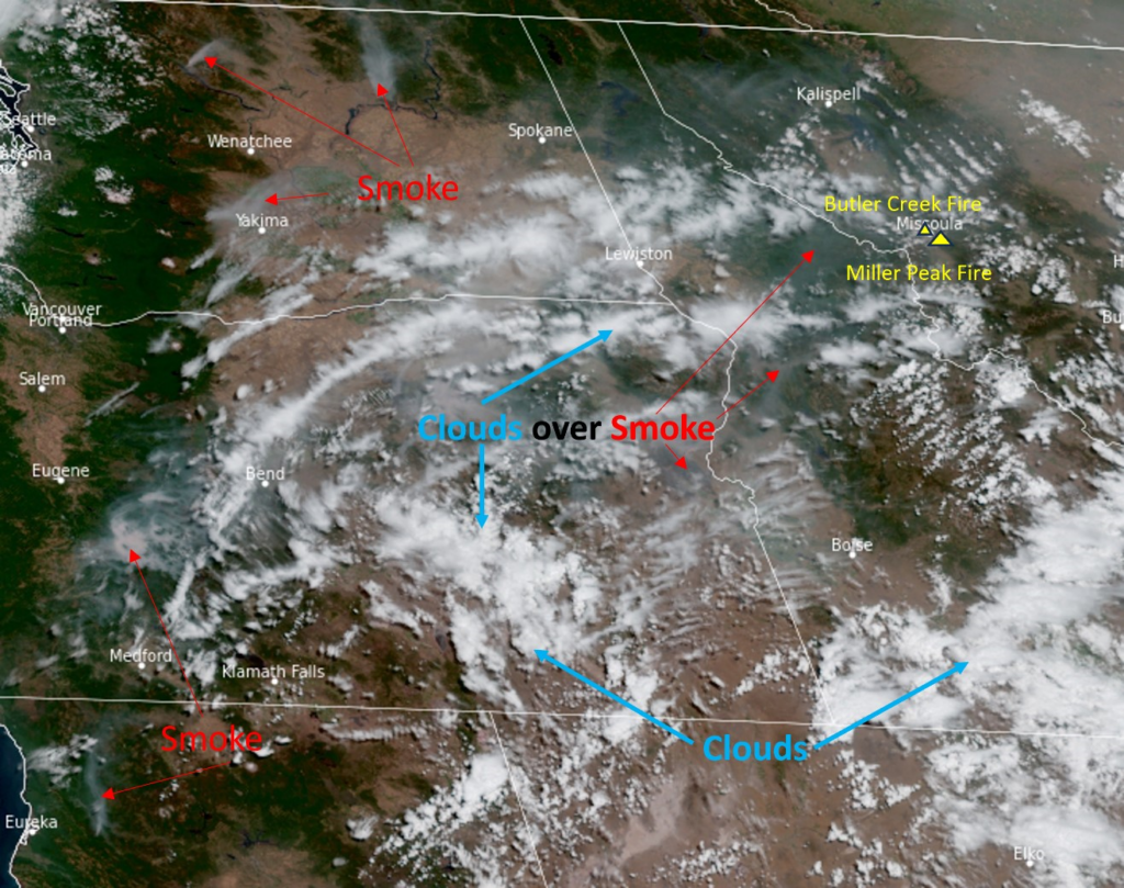
Most of Missoula County is enduring air quality that is Moderate to Unhealthy for Sensitive Groups. Levels of PM2.5 have been pretty consistent all day. Recently, the haze across the county is traveling from fires in Oregon and California, whereas earlier this week wind was carrying smoke from Canada. The whole state of Montana is in a similar boat as Missoula County (maybe some are slightly more afloat); Smoke Forecasts by MT DEQ are really helpful to stay up to date on the rest of the state. Missoula County will likely stay hazy due to the smoke being blown this way, but strong wind gusts this afternoon and tomorrow afternoon may push this smoke out of the valleys that are holding onto it too tightly. From the images taken by the GOES 18 satellite, you can see a lot of active fires further west with distinct plumes. The wind is moving smoke from Northern California and Oregon northeast towards Missoula, currently. 

Moderate air quality has possible health effects on people, but are typically less noticeable than when the air quality gets to Unhealthy for Sensitive Groups. When air pollution is between 100 and 150 AQI (USG), it increases symptoms of smoke exposure in those with heart and lung diseases, children, elderly, pregnant persons, outdoor workers, and people of lower socioeconomic status. This can look anything like respiratory irritation, strain on the cardiovascular system, reduced lung function, and more. Smoke exposure weakens our immune systems so reducing exposure is critical to staying healthy during wildfire season. It’s possible to reduce smoke exposure by breathing clean, filtered air. Thankfully, HEPA filters in a portable air cleaner or HVAC MERV filters with a rating over 13 can remove smoke particles from air inside! Read through the resources at Montanawildfiresmoke.org for more information on cleaning your indoor air and staying healthy this smoky summer. The extremely hot temperatures this summer makes staying healthy during wildfire season even more complicated. Heat is immediately dangerous to our health and causes heat stress and heat related illnesses. When battling heat and smoke, address heat first and then smoke. Stay hydrated and take breaks inside places with cooled and filtered air. If you need to cool your home, open your windows at night and then run your air cleaner once your space has cooled down.

The monitor on the Fire and Smoke Map closest to the Miller Peak Fire is recording Unhealthy levels of PM2.5, but just a couple miles down the road the air monitor is reading Unhealthy for Sensitive Groups. When levels of PM2.5 are in the Unhealthy range, there’s a lot of particulate matter floating around and it can impact everyone’s health, especially sensitive groups. Outdoor recreation and prolonged exertion outdoors should be heavily limited; clean indoor air spaces should be sought out or created at home.

Firefighter crews have been working hard on the Butler Creek Fire and is now 70% contained! The Miller Peak Fire has slowed and it’s reported to be 25% contained.  The current weather conditions of high temperatures and strong gusts of wind have spurred Red Flag Warnings for today and tomorrow and a Heat Advisory until tomorrow night issued by the National Weather Service. Weather conditions can drastically change how a fire behaves, so we’ll be keeping a close eye on the progression of the Miller Peak Fire. A HUGE thanks to all of the people working tirelessly to contain both of these fires so close to Missoula!

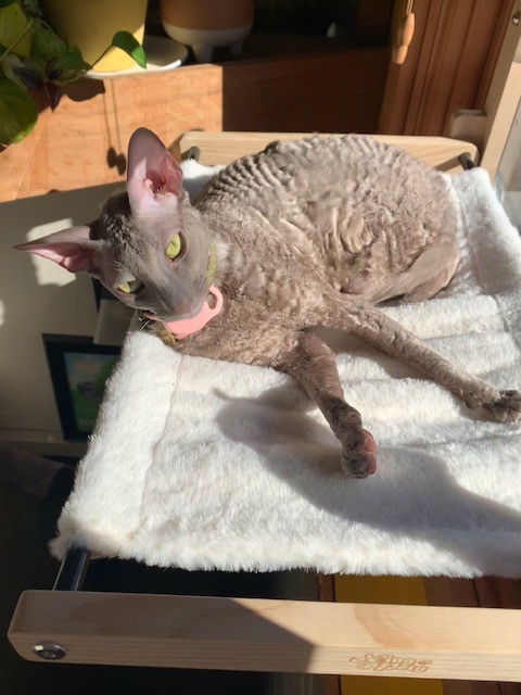
For now, Mushu, your local air quali-kitty (sorry for the typo yesterday!), is hanging out inside clean indoor air but still enjoying that wonderful sunshine! Breathe safe and stay updated on changing air quality by checking the Fire and Smoke Map.

\r\n\r\n<\/div>"},"imageFolderURL":"https:\/\/missoulapublichealth.org\/wp-content\/plugins\/wp-google-maps\/images\/","resturl":"https:\/\/missoulapublichealth.org\/wp-json\/wpgmza\/v1","restnonce":"771212afeb","restnoncetable":{"\/(polygons|polylines|circles|rectangles|pointlabels)(\\\/\\d+)?\/":"eaf7fa9e2b","\/markers(\\\/\\d+)?\/":"6be066e01c","\/datatables":"1096539db4"},"settings":{"engine":"google-maps","internal_engine":"legacy","google_maps_api_key":false,"default_marker_icon":"https:\/\/missoulapublichealth.org\/wp-content\/plugins\/wp-google-maps\/images\/spotlight-poi3.png","developer_mode":false,"user_interface_style":"default","wpgmza_gdpr_enabled":1,"wpgmza_gdpr_default_notice":"

\r\n\tI agree for my personal data to be processed by <\/span>, for the purpose(s) of <\/span>.\r\n<\/p>\r\n\r\n

\t\r\n\tI agree for my personal data, provided via map API calls, to be processed by the API provider, for the purposes of geocoding (converting addresses to coordinates), reverse geocoding and\tgenerating directions.\r\n<\/p>\r\n

\r\n\tSome visual components of WP Go Maps use 3rd party libraries which are loaded over the network. At present the libraries are Google Maps, Open Street Map, jQuery DataTables and FontAwesome. When loading resources over a network, the 3rd party server will receive your IP address and User Agent string amongst other details. Please refer to the Privacy Policy of the respective libraries for details on how they use data and the process to exercise your rights under the GDPR regulations.\r\n<\/p>\r\n

\r\n\tWP Go Maps uses jQuery DataTables to display sortable, searchable tables, such as that seen in the Advanced Marker Listing and on the Map Edit Page. jQuery DataTables in certain circumstances uses a cookie to save and later recall the \"state\" of a given table - that is, the search term, sort column and order and current page. This data is held in local storage and retained until this is cleared manually. No libraries used by WP Go Maps transmit this information.\r\n<\/p>\r\n

\r\n\tPlease see here<\/a> and here<\/a> for Google's terms. Please also see Google's Privacy Policy<\/a>. We do not send the API provider any personally identifying information, or information that could uniquely identify your device.\r\n<\/p>\r\n

\r\n\tWhere this notice is displayed in place of a map, agreeing to this notice will store a cookie recording your agreement so you are not prompted again.\r\n<\/p>","wpgmza_gdpr_company_name":"Missoula Public Health","wpgmza_gdpr_retention_purpose":"displaying map tiles, geocoding addresses and calculating and display directions.","wpgmza_gdpr_button_label":"I agree","wpgmza_marker_xml_url":"https:\/\/missoulapublichealth.org\/wp-content\/uploads\/wp-google-maps\/","wpgmza_maps_engine":"google-maps","wpgmza_maps_engine_dialog_done":true,"wpgmza_google_maps_api_key":"QUl6YVN5QXJINkVnQ0JBd3NBX3JybjBtVWhJVng4elFUSkU1MlIw","tile_server_url":"https:\/\/{a-c}.tile.openstreetmap.org\/{z}\/{x}\/{y}.png","action":"wpgmza_save_settings","wpgmza_settings_map_full_screen_control":false,"wpgmza_settings_map_streetview":false,"wpgmza_settings_map_zoom":false,"wpgmza_settings_map_pan":false,"wpgmza_settings_map_type":false,"wpgmza_settings_map_tilt_controls":false,"wpgmza_settings_map_scroll":false,"wpgmza_settings_map_draggable":false,"wpgmza_settings_map_clickzoom":false,"wpgmza_settings_cat_logic":"0","wpgmza_settings_filterbycat_type":"1","use_fontawesome":"4.*","tile_server_url_override":"","wpgmza_load_engine_api_condition":"where-required","wpgmza_always_include_engine_api_on_pages":"","wpgmza_always_exclude_engine_api_on_pages":"","wpgmza_prevent_other_plugins_and_theme_loading_api":false,"wpgmza_settings_access_level":"manage_options","wpgmza_settings_retina_width":"","wpgmza_settings_retina_height":"","wpgmza_force_greedy_gestures":false,"disable_lightbox_images":false,"gallery_item_source_size":null,"wpgmza_settings_image_resizing":false,"wpgmza_settings_image_width":"","wpgmza_settings_image_height":"","wpgmza_settings_infowindow_width":"","wpgmza_settings_infowindow_links":false,"wpgmza_settings_infowindow_address":false,"infowindow_hide_category":false,"wpgmza_settings_infowindow_link_text":"","wpgmza_settings_map_open_marker_by":"1","wpgmza_settings_disable_infowindows":false,"wpgmza_settings_markerlist_icon":false,"wpgmza_settings_markerlist_link":false,"wpgmza_settings_markerlist_title":false,"wpgmza_settings_markerlist_address":false,"wpgmza_settings_markerlist_category":false,"wpgmza_settings_markerlist_description":false,"wpgmza_do_not_enqueue_datatables":false,"wpgmza_default_items":null,"wpgmza_settings_carousel_markerlist_theme":null,"wpgmza_settings_carousel_markerlist_image":false,"wpgmza_settings_carousel_markerlist_title":false,"wpgmza_settings_carousel_markerlist_icon":false,"wpgmza_settings_carousel_markerlist_address":false,"wpgmza_settings_carousel_markerlist_description":false,"wpgmza_settings_carousel_markerlist_marker_link":false,"wpgmza_settings_carousel_markerlist_directions":false,"wpgmza_settings_carousel_markerlist_resize_image":false,"carousel_lazyload":false,"carousel_autoheight":false,"carousel_pagination":false,"carousel_navigation":false,"wpgmza_do_not_enqueue_owl_carousel":false,"wpgmza_do_not_enqueue_owl_carousel_themes":false,"carousel_items":"5","carousel_items_tablet":"3","carousel_items_mobile":"1","carousel_autoplay":"5000","wpgmza_store_locator_radii":"","importer_google_maps_api_key":"","open_layers_api_key":"","open_route_service_key":"","wpgmza_settings_marker_pull":"0","wpgmza_custom_css":"","wpgmza_custom_js":"","disable_compressed_path_variables":false,"disable_autoptimize_compatibility_fix":false,"enable_dynamic_sql_refac_filter":false,"disable_automatic_backups":false,"disable_google_fonts":false,"wpgmza_developer_mode":false,"wpgmza_gdpr_require_consent_before_load":false,"wpgmza_gdpr_override_notice":false,"wpgmza_gdpr_notice_override_text":"","accessLevel":"manage_options","alwaysExcludeEngineApiOnPages":"","alwaysIncludeEngineApiOnPages":"","carouselAutoplay":"5000","carouselItems":"5","carouselItemsMobile":"1","carouselItemsTablet":"3","carouselMarkerlistResizeImage":false,"carouselTheme":null,"categoryFilterDisplay":"dropdown","categoryFilteringLogic":"or","customCss":"","customJs":"","defaultMarkerIcon":"https:\/\/missoulapublichealth.org\/wp-content\/plugins\/wp-google-maps\/images\/spotlight-poi3.png","developerMode":false,"disableAutomaticBackups":false,"disableAutoptimizeCompatibilityFix":false,"disableCompressedPathVariables":false,"disableDoubleClickZoom":false,"disableDragPanning":false,"disableFullScreenControl":false,"disableGoogleFonts":false,"disableInfoWindows":false,"disableLightboxImages":false,"disableMouseWheelZoom":false,"disablePanControl":false,"disableStreetViewControl":false,"disableTypeControl":false,"disableZoomControl":false,"doNotEnqueueDatatables":false,"doNotEnqueueOwlCarousel":false,"doNotEnqueueOwlCarouselThemes":false,"enableCarouselAutoHeight":false,"enableCarouselLazyLoad":false,"enableCarouselNavigation":false,"enableCarouselPagination":false,"enableDynamicSqlRefacFilter":false,"forceGreedyGestures":false,"galleryItemSourceSize":null,"gdprButtonLabel":"I agree","gdprCompanyName":"Missoula Public Health","gdprDefaultNotice":"

\r\n\tI agree for my personal data to be processed by <\/span>, for the purpose(s) of <\/span>.\r\n<\/p>\r\n\r\n

\t\r\n\tI agree for my personal data, provided via map API calls, to be processed by the API provider, for the purposes of geocoding (converting addresses to coordinates), reverse geocoding and\tgenerating directions.\r\n<\/p>\r\n

\r\n\tSome visual components of WP Go Maps use 3rd party libraries which are loaded over the network. At present the libraries are Google Maps, Open Street Map, jQuery DataTables and FontAwesome. When loading resources over a network, the 3rd party server will receive your IP address and User Agent string amongst other details. Please refer to the Privacy Policy of the respective libraries for details on how they use data and the process to exercise your rights under the GDPR regulations.\r\n<\/p>\r\n

\r\n\tWP Go Maps uses jQuery DataTables to display sortable, searchable tables, such as that seen in the Advanced Marker Listing and on the Map Edit Page. jQuery DataTables in certain circumstances uses a cookie to save and later recall the \"state\" of a given table - that is, the search term, sort column and order and current page. This data is held in local storage and retained until this is cleared manually. No libraries used by WP Go Maps transmit this information.\r\n<\/p>\r\n

\r\n\tPlease see here<\/a> and here<\/a> for Google's terms. Please also see Google's Privacy Policy<\/a>. We do not send the API provider any personally identifying information, or information that could uniquely identify your device.\r\n<\/p>\r\n

\r\n\tWhere this notice is displayed in place of a map, agreeing to this notice will store a cookie recording your agreement so you are not prompted again.\r\n<\/p>","gdprEnabled":1,"gdprNoticeOverrideText":"","gdprOverrideNotice":false,"gdprRequireConsentBeforeLoad":false,"gdprRetentionPurpose":"displaying map tiles, geocoding addresses and calculating and display directions.","googleMapsApiKey":"QUl6YVN5QXJINkVnQ0JBd3NBX3JybjBtVWhJVng4elFUSkU1MlIw","hideCarouselMarkerListingAddress":false,"hideCarouselMarkerListingDescription":false,"hideCarouselMarkerListingDirections":false,"hideCarouselMarkerListingIcon":false,"hideCarouselMarkerListingImage":false,"hideCarouselMarkerListingLink":false,"hideCarouselMarkerListingTitle":false,"hideMarkerListingAddress":false,"hideMarkerListingCategory":false,"hideMarkerListingDescription":false,"hideMarkerListingIcon":false,"hideMarkerListingLink":false,"hideMarkerListingTitle":false,"importerGoogleMapsApiKey":"","infoWindowAddress":false,"infoWindowHideCategory":false,"infoWindowImageHeight":"","infoWindowImageResizing":false,"infoWindowImageWidth":"","infoWindowLinkText":"","infoWindowLinks":false,"infoWindowMaxWidth":"","internalEngine":"legacy","loadEngineApiCondition":"where-required","mapTiltControls":false,"mapsEngineDialogDone":true,"markerListingPageSize":null,"markerPull":"database","markerXmlUrl":"https:\/\/missoulapublichealth.org\/wp-content\/uploads\/wp-google-maps\/","openInfoWindowEvent":"click","openLayersApiKey":"","openRouteServiceKey":"","preventOtherPluginsAndThemeLoadingApi":false,"retinaHeight":"","retinaWidth":"","storeLocatorRadii":"","tileServerUrl":"https:\/\/{a-c}.tile.openstreetmap.org\/{z}\/{x}\/{y}.png","tileServerUrlOverride":"","useFontAwesome":"4.*","userInterfaceStyle":"default"},"stylingSettings":{},"currentPage":null,"userCanAdministrator":"0","serverCanInflate":"1","localized_strings":{"unsecure_geolocation":"Many browsers are no longer allowing geolocation from unsecured origins. You will need to secure your site with an SSL certificate (HTTPS) or this feature may not work for your visitors","use_my_location":"Use my location","google_api_not_loaded":"The map cannot be initialized because the Maps API has not been loaded. Please check your settings.","no_google_maps_api_key":"You have not entered a Google Maps API Key<\/b>.

Please go to the your admin area, then Maps, then Settings, then the Advanced tab to
enter your Google Maps API key<\/a>.

Alternatively,
choose the Open Layers engine<\/a> to avoid getting an API key.","documentation":"Documentation","api_dashboard":"API Dashboard","verify_project":"Verify Project","no_shape_circle":"Please create the circle first.","no_shape_rectangle":"Please create the rectangle first.","no_shape_polygon":"Please create the polygon first.","no_shape_polyline":"Please create the polyline first.","failed_to_get_address":"Failed to get address","failed_to_create_marker":"Failed to create marker %d - this marker cannot be placed on the map.","my_location":"My Location","kilometers_away":"km away","miles_away":"miles away","import_completed":"Import completed.","importing_please_wait":"Importing, this may take a moment...","no_address_specified":"No address specified","add_marker":"Add Marker","save_marker":"Save Marker","please_wait":"Please Wait...","zero_results":"No results found in this location. Please try again.","address_not_found":"This address could not be found. WP Go Maps uses a 3rd party service (eg Google) to convert addresses to geographic coordinates. Unfortunately, the service has no records for this address at present. Please try an alternative format, or manually position the marker using right click.","geocode_fail":"Geocode failed due to technical reasons","you_must_check_gdpr_consent":"You must check the GDPR consent box to continue","no_gps_coordinates":"No GPS coordinates found","fetching_directions":"Fetching directions...","unknown_directions_service_status":"Unknown directions service status","please_fill_out_both_from_and_to_fields":"Please fill out both the \"from\" and \"to\" fields","no_picture_found":"No picture found","overwrite_theme_data":"Are you sure you want to overwrite the existing theme data?","upload_complete":"Upload Complete","uploading_file":"Uploading file","bulk_jpeg_media_title":"WP Go Maps - Bulk JPEG Upload","from_your_location":"from your location","from_searched_location":"from searched location","yes":"Yes","no":"No","requires_gold_v5":"Requires WP Go Maps - Gold add-on 5.0.0 or above","confirm_remove_duplicates":"This operation is not reversable. We recommend you take a backup before proceeding. Would you like to continue?","invalid_theme_data":"Invalid theme data","duplicate_custom_field_name":"Duplicate custom field names, please ensure you only add unique custom field names.","disabled_interactions_notice":"Some interactions are disabled.","interactions_enabled_notice":"Interactions Enabled","disabled_interactions_button":"Re-Enable Interactions","use_two_fingers":"Use two fingers to move the map","use_ctrl_scroll_to_zoom":"Use ctrl + scroll to zoom the map","geocode_was_not_successful":"Geocode was not successful for the following reason: ","geocoding_library_notice":"Geocoding this address failed. Please check you have enabled the Geocoding API for your Google Maps API project.","map_delete_prompt_text":"Are you sure you want to delete this map?","map_bulk_delete_prompt_text":"Are you sure you want to delete these maps?","general_delete_prompt_text":"Are you sure you want to delete this data?","new_map":"New Map","all":"All","cloud_api_key_error_1":"Autocomplete disabled. Find out more<\/a>."},"api_consent_html":"

\r\n\tI agree for my personal data to be processed by Missoula Public Health<\/span>, for the purpose(s) of displaying map tiles, geocoding addresses and calculating and display directions.<\/span>.\r\n<\/p>\r\n\r\n

\t\r\n\tI agree for my personal data, provided via map API calls, to be processed by the API provider, for the purposes of geocoding (converting addresses to coordinates), reverse geocoding and\tgenerating directions.\r\n<\/p>\r\n

\r\n\tSome visual components of WP Go Maps use 3rd party libraries which are loaded over the network. At present the libraries are Google Maps, Open Street Map, jQuery DataTables and FontAwesome. When loading resources over a network, the 3rd party server will receive your IP address and User Agent string amongst other details. Please refer to the Privacy Policy of the respective libraries for details on how they use data and the process to exercise your rights under the GDPR regulations.\r\n<\/p>\r\n

\r\n\tWP Go Maps uses jQuery DataTables to display sortable, searchable tables, such as that seen in the Advanced Marker Listing and on the Map Edit Page. jQuery DataTables in certain circumstances uses a cookie to save and later recall the \"state\" of a given table - that is, the search term, sort column and order and current page. This data is held in local storage and retained until this is cleared manually. No libraries used by WP Go Maps transmit this information.\r\n<\/p>\r\n

\r\n\tPlease see here<\/a> and here<\/a> for Google's terms. Please also see Google's Privacy Policy<\/a>. We do not send the API provider any personally identifying information, or information that could uniquely identify your device.\r\n<\/p>\r\n

\r\n\tWhere this notice is displayed in place of a map, agreeing to this notice will store a cookie recording your agreement so you are not prompted again.\r\n<\/p>